My Second (and Third!) Geocache Find
2008-04-24 21:20 - General
I just mentioned the other day that as part of the vacation I'm on, I took up Geocaching. I'm happy to have had the chance to start it in a spot where I have access to nice wooded areas, as I'm sure that's where it's best. At home in the city, it's surely a different beast.
Anyways, yesterday we headed out to play some mini golf. Turns out the local place my Dad knew was closed and boarded up. And maybe not really a mini golf course. We looked up another place in the phone book at a gas station on the corner, and his navigation unit took us there. It was an office park, not mini golf. So we gave up and came home, and started looking more carefully.
We found one, but a half hour drive away. We decided to look up where it was, and find a cache or two to seek out, if we felt like it when we were done. We got lucky, it was only a minute or two away from a little park, already on the way. The park turned out to be chock full of potential caches to seek.

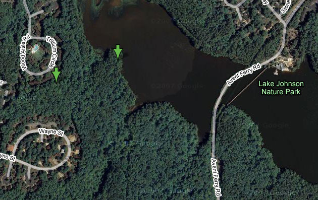
Image credit: Google Maps
You can see Lake Johnson, the centerpiece of the park, in this picture. You can't see, however, the trail we took, as you could last time. This was a very un-paved trail, following (more or less) the edge of the lake. We parked in the space you can barely see towards the right of the "Avent Ferry Rd" notation, south of the lake. It was a bit of a hike from there as you can tell from the picture. My GPS unit measured the hike back as 0.6 miles, and there were plenty of hills along the way.
That second day, we were better prepared. We took printouts of both the linked cache description pages. The first of the two sat near the end of a small peninsula, somewhat clear from the picture. There was a little bench at the end of this peninsula, and as the cache described, it offered a wonderful view of the lake. After a short, and successful, hunt for that cache, we sat there for a bit, both to rest and enjoy the view.
The second cache was a different story. It's not at all obvious from the satellite view, but the coordinates led us to a bend in a tiny creek, below a 20-or-so foot cliff of sorts. We started at the bottom, and looked and looked, and then looked some more, with no success.
Finally, we gave up and decoded the hint. It gave rather clear instructions, but it still took quite a bit of looking. The cache ended up being on top of the cliff-of-sorts, which we would have known if we read the comments. At the end, we did find both caches for the day, however! Left (and took) nothing but notes in the log book, but the hike and the finds were quite a lot of fun. The much better two-for-two, over one-for-four, find record was also nice.